
OBSERVATÓRIO VULCANOLÓGICO E GEOTÉRMICO DOS AÇORES
O OVGA é um Centro de Ciência que desenvolve atividade de investigação aplicada e de divulgação científica na área da Vulcanologia, da Sismologia e da Geotermia.


Notícia -A A +A
Erupção do Monte St. Helens: Factos e Informações (texto original em Inglês) - Notícia 19-10-2018
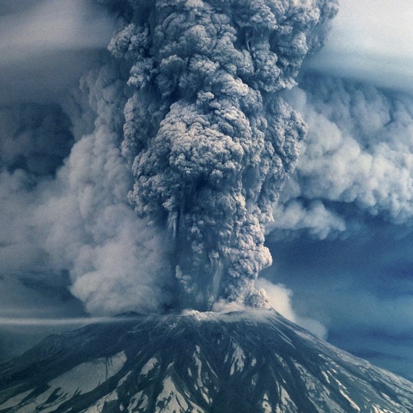
Foto aérea da erupção do Monte St. Helens em 1980 (fase pliniana).
Créditos: earthsky.org
Mount St. Helens was once a beautiful, symmetrical example of a stratovolcano in the Cascades mountain range in southwestern Washington, rising to 9,600 feet (3,000 meters) above sea level. Then, on May 18, 1980, the once-quiet volcano erupted and blasted off the upper 1,000 feet (300 m) of the summit. A horseshoe-shaped crater and a barren wasteland were all that remained.
Since then, the land has healed and recovered much of its natural beauty, but it's likely Mount St. Helens won't stay quiet forever.
Geologic records suggest the volcano has gone through several stages of activity, according to the U.S. Geological Survey (USGS). Since at least 1800, the volcano experienced a period of intermittent eruptions until 1857, then a few minor, steam-driven eruptions in 1998, 1903 and 1921. Otherwise, the volcano remained relatively peaceful throughout the 20th century and was a popular recreational area until its 1980 eruption.
On shaky ground
On March 1, 1980, the University of Washington installed a new system of seismographs to monitor earthquake activity in the Cascades, especially around Mount St. Helens, where there had been a recent increase in seismic activity. According to the Department of Geological Sciences at San Diego State University, the first key indication that major volcanic activity was imminent was when a 4.2-magnitude earthquake rumbled below Mount St. Helens on March 20.
Just three days later, on March 23, a 4.0-magnitude earthquake shook the ground and set off a chain of smaller-magnitude earthquakes — about 15 per hour. The shaking continued and began to intensify over the next couple of days. By March 25, seismographs were detecting an average of three, 4.0-magnitude quakes every hour. Aerial observations revealed new fractures in the surrounding glaciers and numerous rockslides.
Around noon local time on March 27, tension was released as the peak of Mount St. Helens burst open, shooting steam 6,000 feet (1,829 meters) into the air and blasting a 250 foot-wide crater (75 meter) through the summit, according to USGS.
Smaller eruptions continued at a rate of about one per hour throughout March, then decreased to about one per day in April until they stopped on April 22. On May 7, eruptions started back up again, and the rate of eruptions gradually increased for the next 10 days. By May 17, the north side of the volcano had bulged out about 450 feet (140 m) nearly horizontally, indicating that magma was rising toward the summit of the volcano and pressure was building.
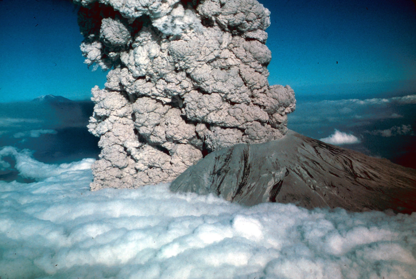
Nesta fotografia de uma erupção do Monte St. Helens, no dia 22 de julho de 1980, é possível observar uma corrente piroclástica, à esquerda.
Créditos: USGS / Jim Vallance
"This is it!"
On the morning of May 18, USGS volcanologist David Johnston, woke up at his campsite on a ridge 6 miles north of the volcano, and radioed in his regular 7 a.m. report. The changes to the bulging mountain were consistent with what had been reported several times daily since the watch began and left no indication of what was about to happen, according to USGS.
At 8:32 a.m., a magnitude-5.1 earthquake registered on the seismographic equipment about 1 mile beneath the volcano. His excited radio message, "This is it!" was followed by a stream of data. It was his last transmission; the ridge he camped on was within the direct blast zone.
Overhead, Keith and Dorothy Stoffel were making an aerial survey of the volcano when they noticed a landslide on the lip of the summit's crater, USGS reported. Within seconds, the whole north face of the mountain was on the move. Just as they passed around to the east side of the mountain, the north face collapsed, releasing superheated gases and trapped magma in a massive lateral explosion. Keith put the plane into a steep dive to gain the speed to outrun the cloud of incandescent gas; Dorothy continued to photograph the eruption through the rear windows of the plane as they made their escape.
The abrupt release of pressure over the magma chamber created a “nuée ardente,” a glowing cloud of superheated gas and rock debris blown out of the mountain face moving at nearly supersonic speeds. Everything within eight miles of the blast was wiped out almost instantly, according to USGS. The shockwave rolled over the forest for another 19 miles, leveling century-old trees; all the trunks neatly aligned to the north. Beyond this “tree down zone” the forest remained standing but was seared lifeless. The area devastated by the direct blast force covered an area of nearly 230 square miles (596 square kilometers).
Shortly after the lateral blast, a second, vertical explosion occurred at the summit of the volcano, sending a mushroom cloud of ash and gases more than 12 miles (19 km) into the air. Over the next few days, an estimated 540 million tons (490,000 kilotons) of ash drifted up to 2,200 square miles (5,700 square km), settling over seven states.
The heat of the initial eruption melted and eroded the glacial ice and snow around the remaining part of the volcano. The water mixed with dirt and debris to create lahars, or volcanic mudflows. According to USGS, the lahars reached speeds of 90 mph (145 km/h), and demolished everything in their path. Most of the glaciers surrounding Mount St. Helens melted, too, and likely contributed to the destructive lahars, Benjamin Edwards, volcanologist and professor of Earth Science at Dickinson College in Pennsylvania, told Live Science in an email.
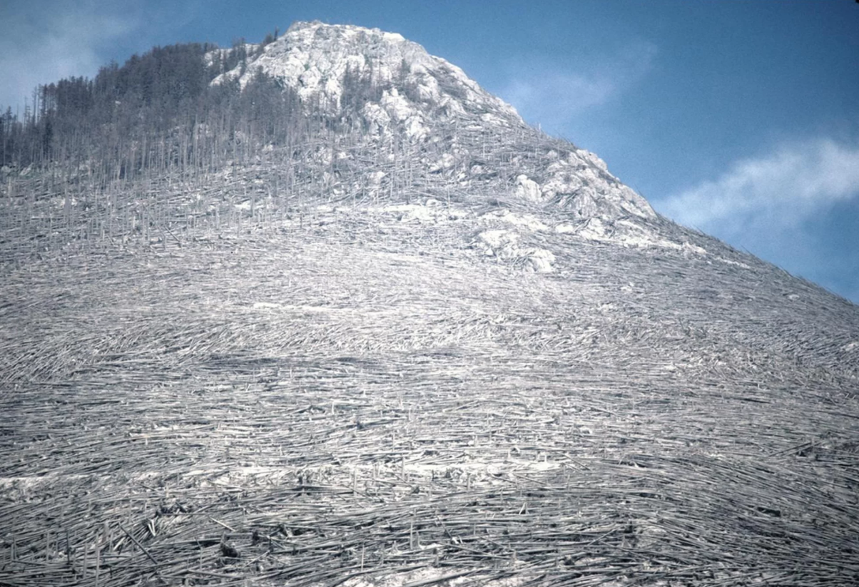
Árvores derrubadas e arrancadas como consequência da explosão lateral (“blast”) aquando da erupção do dia 18 de maio de 1980.
Créditos: USGS
Most destructive U.S. volcano
The 1980 Mount St. Helens eruption was the most destructive in U.S. history. Fifty-seven people died, and thousands of animals were killed, according to USGS. More than 200 homes were destroyed, and more than 185 miles of roads and 15 miles of railways were damaged. Ash clogged sewage systems, damaged cars and buildings, and temporarily shut down air traffic over the Northwest.
The International Trade Commission estimated damages to timber, civil works and agriculture to be $1.1 billion. Congress approved $950 million in emergency funds to the Army Corps of Engineers, the Federal Emergency Management Agency and the Small Business Administration to help with recovery efforts.
Will Mount St. Helens erupt again?
Today, scientists keep a close watch on Mount St. Helens and other volcanoes in the Pacific Northwest. The volcano's location on the Cascadian Subduction Zone means another eruption is inevitable, Howard R. Feldman, chair of geology and environmental science at Touro College in New York, told Live Science. But predicting when that will happen is extremely difficult.
Long-term seismic data is key to knowing when a volcano might be on the verge of erupting, Edwards said. A jump in the number of earthquakes over the course of a week, or even a day, can signal the start of new activity.
For the last few years, the seismic activity going on around Mount St. Helens has fallen within the normal range, as data from the Pacific Northwest Seismic Network suggest.
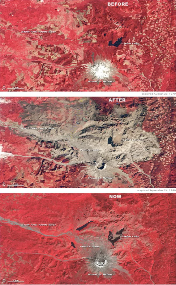
Em 2010, o satélite Landsat da NASA forneceu 3 imagens com cores selecionadas documentando a destruição e a recuperação do Monte St. Helens. A vegetação é vista a vermelho, as rochas e detritos vulcânicos a cinzento e a água surge a azul escuro. A imagem central revela a enorme cicatriz cinzenta da destruição causada pelo fantástico evento.
Créditos: NASA / Landsat / Earth Observatory
The 1979 view (top) shows the snow-covered summit of the perfectly shaped stratovolcano, and the mixture of protected forest (darkest red, north of the volcano), agricultural land (lighter reds), and logging clear cuts (patchwork of squares at image right) that surrounded the mountain, researchers at NASA's Earth Observatory explained.
The image from Sept. 24, 1980 (middle), shows the devastation of the eruption. The northern flank of the mountain collapsed, producing the largest landslide in recorded history. The avalanche buried 14 miles (23 kilometers) of the North Fork Toutle River with an average of 150 feet (46 meters) — but in places up to 600 feet (180 meters) — of rocks, dirt, and trees. The blast spread rock and ash (gray in the images) over 230 square miles (600 square kilometers). A raft of dead trees floats across Spirit Lake. Volcanic mudflows (lahars) poured down rivers and gullies around the intact flanks.
Three decades later, the bottom image (from Sept. 10, 2009) shows the recovery in the blast zone. Most of the landscape within the blast zone has at least a tinge of red, meaning vegetation has recolonized the ground. The flanks of the volcano itself are still bare, as is a broad expanse north of the volcano called the Pumice Plain.
Directly in the path of the landslide and several pyroclastic flows, this area has been slowest to recover. Ground surveys, however, have found even this seemingly barren area is coming back to life: the first plant to re-appear was a prairie lupine, which can take nitrogen—a critical plant nutrient—straight from the air rather than from the soil. These small wildflowers begin the crucial task of rebuilding the soil and attracting insects and herbivores. This process is underway on the Pumice Plain, even though it is not yet visible from space, scientists said.
Fonte: livescience
Relator: Pedro Correia